by Jeffrey Parnes
- Attendees
- Members: Howard Green (Roan Stallion POA), Carol Hawn (Old Mill), Jay Johnston (Virginia Run), Georgette Kohler (Rock Hill Civic Assoc), Mark McConn (Bull Run Civic Assoc), Jeffrey Parnes (Chantilly Highlands), Dave Sanders (Horseworks) and Larry Tessier (Franklin Glen).
- Guests: Bill Baskin, Bruce McKinley, Dean Mojette, Mike Saunders (Ox Hill Church), Roch Koch (Sully Planning Commissioner), Keith Martin (Walsh, Colucci, Stackhouse, Emrich & Lubeley, P.C.), Frank McDermott (Hunton & Williams), Bhoopendra Paukash (The Plans Source Exxon), Roger Riggins (K. Hovnanian Co.), and Jeff Saxe (Peterson Cor)
- Presentations:
- 7:30
- Proponent: Jeff Saxe for Peterson Cos.
- Action: Out-of-Turn Plan Amendment to incorporate residential in mixed use
- Location: East of Rt 28 at Air & Space Annex Parkway Interchange
- Vinyl siding
- On street and visitor parking
- Antipode (noise contours)
- Lighting
- Wall Road
Last presented in July 2003, Jeff Saxe returned to provide further information on the attempt to incorporate residential development into the planned Dulles Discovery development.
The proposed Out-of-Turn Plan Amendment to incorporate residential in mixed use is scheduled for the Planning Commission in September, the Board of Supervisors in October and the Board of Zoning Appeals in November.
The Peterson Company has purchased and cleaned up two of the three industrial sites that were on Barnsfield Road. They have been unsuccessful in their attempt to purchase the third, the Cox Property, but have incorporated access routes to it from their proposed development.
The site, which is planned as an I5 district, is proposed as PDC north of the current Barnsfield Road and PDH south. The housing component is planned as a senior citizen development, with restrictions as to targeted residents (55 years) and no children under 18 allowed to be permanent residents.
The previous plans had shown a retail element south of the current Barnsfield road and senior moderate-income rental housing north, and they have been switched in this iterative of the plan.
They are proposing 79 two-story multi-family villas, comprised of structures with two, three or four units each south of Lees Corner Road extended and along Centreville Road. The units would have vinyl siding and vary in size between 2500 and 2900 square feet. The master bedrooms would be on the first floor with the 2nd floor available for lofts or additional bedrooms. Each unit will have a two-car garage as well as a driveway that will allow parking for two additional cars. The community center structure with meeting rooms, gym, and other services, and allow for additional parking, will be located in the midst of the villas. Additional on-street parking will be allowed one side of the private streets.
The four-story multi-family apartment structures will have underground garages and elevators. Each unit will have nine apartments per floor for 36 units per building. There will be at least one parking spot per apartment, with surface open parking nearby. The average apartment will be 1600 square feet, with one bedroom plus den units at 1600 square feet, and two-bedroom plus den units at 2000 square feet.
They project 75%-80% of their traffic will enter from Rt. 28 with the remainder coming from Centreville Road. In conformance with current plans, Barnsfield road will be abandoned, with traffic from Centreville coming from Lees Corner Road from the south and Wall Road from the north. They will build frontage improvements along their portion of Wall Road, and have an agreement with EDS as to where their access roads will cross Wall Road.
Access to the Sully Historic site will be through their residential area off the east side of the Air & Space Annex parkway, with the current entrance on Rt. 28 closed when that happen. Sully attracts 30 thousand vehicles per year, with two peak weekends (antique car and quilting displays). The replanned access road avoids the remains of the of Manassas Gap Railroad right of way. The fence along the Sully access road has not been resolved.
Their current plans call for an FAR of .65 as opposed to their allowed 1.0.
The committee identified several concerns and asked that they be addressed at our July meeting (which was rescheduled to 28 June due to the Independence Day holiday on 5 July):
- 8:00
- Proponent: Bill Baskin for Ox Hill Baptist Church
- Action: Rezoning (R1 to R12) and concurrent Special Exception
- Location: Elmwood Street, off Lee Jackson Memorial Highway (Rt. 50), south of the existing BB&T bank.
- Expand Parking and improve infrastructure
- Construct two-story structure with basement to include kitchen, gym, education space and elevator
- Connect both buildings
- Sanctuary expansion (from 300 to 600), and parking build out (to 291 spaces).
- Parking lot lights, trees on border between residential community and church
- The results of their meeting with the adjoining community
- Review surface water management plan for impervious surface
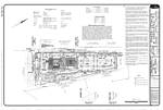 Generalized Development Plan, Special Exemption Plat (2.33 MB)
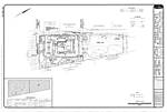 Existing Conditions (1.82MB)
 Phasing Plan (1.67MB)
The church seeks to rezone the subject property in accordance with their 15-Year / 4-Phase Master Plan. The proposed expansion is based on the projected church growth over the next 15 to 20 years and the efficient use of this site. Currently, over 40% of the church property is vacant (Parcel 54A). As depicted on the Phasing Plan, the church envisions a systematic development of this site with the initial expansion of the parking area and all relevant site improvements to support the subsequent building and program expansion. Additional improvements will include a fellowship hall, kitchen, classrooms, an administration wing, a music suite, and media center and ultimately a new 950-seat sanctuary. The proposed additions to the existing church structure will be built in harmony with the existing pseudo-Georgian or Colonial architecture.
The rezoning is scheduled for a 22 September Planning Commission public hearing.
Each phase of the four-phase development plan is both independent and self-sufficient. The aim of the development is two-fold, the first to continue serving the neighborhood by increasing space for the computer training it works with the county to provide, the second to serve the growth of its congregation.
These expansion plans are expected be built as funds accumulate over the course of 15 plus years. The current FAR on the property is .15; at build out it would be .23. The land is currently R1 and R12 is requested instead of R6 or R8 as R12 allows a church by right rather than by special exception, and a special exception on the current R1 zoning would not allow the desired FAR.
There is a treed 25-foot buffer between the parking lot and the adjoining residential. The proposed recreational area would be open to the residential units.
Water on the parking lots will be routed to a retaining pond, which will not be permanently wet. A filter system inline with the pond discharge will remove silt to give a net improvement of flow off their property.
The committee identified several concerns and asked that they be addressed at our July meeting:
The committee asked for copies of the expansion plans, which the Ox Hill Church furnished. Click on the compresssed plans below to see the full document:
- 8:30
- Proponent: Keith Martin
- Action: PCA/FDPA case, add a quick service food store to existing service bays
- Location: the Exxon on Route 50 at Fair Oaks
Previously considered in January, it is going to PC on in July 04 with the addition of a service bay.
Though the approved plans show 10 pumps, only 8 will be built, including two diesel / gas units. The store will now be 3200 square feet rather than the planned 3700 square feet. This will allow both a new car wash and a four-bay light-service facility. With the replanning, other uses do not exceed the currently approved other uses.
VDOT no longer requires a service drive on the right connecting the site to the fire station. Although the service drive right-of-way on the left will be required, VDOT will allow it to be landscaped in the interim. RT. 50 will be widened to four lanes along the full Rt 50 frontage. Only one entrance from Rt.50 (instead of the originally planned two) will be built.
The facility will be architecturally similar to the existing hotel. There will not be a full sidewalk along Fair Ridge Drive, but there will be pedestrian access from the hotel via interior driveways.
The committee was satisfied with the presentation and had no additional comments.
- 7:30
- Old business:
- None
- New Business:
- Jeff Parnes, Sully's TAC Commissioner, discussed plans to smooth traffic flow on RT. 28 at the Braddock/Walney and Rt 28 intersection, as well as the RT 28/I66 interchange.
With the Private/Public effort underway to remove lights on Rt 28 from Westfields north to Rt 7, these intersections will remain signalized and an unfunded problem.
Jeff met with Fairfax County's Office of Transportation director, Young Ho Chang, to discuss alternatives that could be accomplished with a minimal of expenditures. If the cross traffic from Walney to Braddock could be eliminated, and Rt. 29 west of I66 restriped to three westbound lanes, those residents desiring access to the area south and west of Braddock could go via Stone Road, while those desiring access north and east of Braddock could go via the Westfields interchange now under construction. Then only a short light would be required to allow Braddock Road traffic to turn right onto Rt. 28 south.
Similarly, if northbound Rt. 28 traffic could be directed to southbound Rt. 29 in order to access westbound I66, the light at I-66 and Rt 28 north of I66 could be eliminated. The county will research current vehicle levels on southbound Rt. 29 and examine whether it could be completely restriped to allow three southbound lanes from Rt 28 to I66.
Young Ho Chang will contact Jeff when more information is available.
- Jeff Parnes, Sully's TAC Commissioner, discussed plans to smooth traffic flow on RT. 28 at the Braddock/Walney and Rt 28 intersection, as well as the RT 28/I66 interchange.
- Scheduled Meetings:
- Workshop to Discuss Sully Site Plans
- The county Park Authority has scheduled a workshop at 7 p.m. May 11 on a proposal to update the master plan for the Sully Historic Site in Chantilly.
- Richard Bland Lee, Northern Virginia's first representative to Congress completed the 128-acre Sully site, at 3601 Sully Rd in 1799. The house is furnished with antiques of the Federal period, and outbuildings include a kitchen, smokehouse and stone dairy. Educational programs, craft demonstrations and living history events are offered throughout the year.
- Park officials want to update the site to attract visitors. The May 11 meeting, at Franklin Middle School, is the first step in the planning process and will be followed by a public hearing on a draft plan.
- Comments can be mailed to Angie Allen, project manager, Planning and Development Division, Fairfax County Park Authority, 12055 Government Center Pkwy., Suite 421, Fairfax, Va. 22035. E-mail comments can be sent to parkmail@fairfaxcounty.gov.
- Design Public Hearing - Centreville Road/Rt 657
- Open House Tuesday, 25 May, 5 - 8 PM, with a brief presentation at 6 at Rachel Carson Middle School at 13618 McLearen Road, Oak Hill, VA
- Come and see preliminary plans for the proposed widening of Centreville Road (Route 657), beginning at West Ox Road and ending at Frying Pan Road, in Fairfax County.
- Find out about tentative construction schedules, property impacts and relocation assistance.
- Review the project information at the public hearing or at VDOT's Northern Virginia District Office located at 14685 Avion Parkway, Chantilly, VA. You may also email your comments by writing to Meeting_Comments@VirginiaDOT.org. Please reference "Centreville Road" In the subject heading.
- Cub Run and Bull Run Watershed Management Plan Meeting
- Tuesday, June 8, 2004, 7 - 9 p.m., at Westfield High School Cafeteria, 4700 Stonecroft Blvd in Chantilly
- Who Should Attend? Everyone who lives in the watersheds and cares about the quality of their environment should attend. The watersheds includes portions of western Fairfax County and eastern Loudoun County were surface runoff drains into Cub Run and Bull Run. The attached poster includes a map that the defines the watershed boundaries. If you live in this area, you are affected by the quality of streams in these watersheds.
- Why Should You Participate? This is your community! Streams in the Cub Run and Bull Run watersheds are deteriorating. Aquatic life is disappearing. Stream banks are eroding. All who live and work here have a stake in protecting the streams in the watershed because improved conditions will:
- Protect our drinking water supply in the Occoquan Reservoir
- Help in cleaning up the Potomac River and Chesapeake Bay
- Reduce flooding
- Restore biological diversity in the streams
- Enhance our quality of life
- Why a Watershed Plan? We need to identify and fix water quality and other stream-related problems, at the community level. Fairfax County is working with local residents, businesses, and other agencies to develop a watershed management plan for Cub Run and Bull Run. The plan will set our strategy to solve problems and improve conditions in the watersheds.
- Participation Information: This meeting is open to the open to the public. RSVP to Chuck Moore at (703) 642-5500 or MooreCI@CDM.COM so that we can have an estimate of the number of citizens interested in participating in this forum. Also, please contact Chuck if you have any questions about the watershed plan or the public information process.
- Preliminary Agenda:
- Introduction to Watershed Planning
- Purpose of watershed management plan
- Watershed planning process/schedule
- State of the Cub Run and Bull Run Watersheds
- History of development and its impacts
- Review of past watershed protection efforts
- Breakout Discussions to Identify Watershed Problems and Issues
- Introduction to Watershed Planning
- Help us get the word out! Please forward this notice to others who may be interested in stream conditions in the study area. A PDF poster that you can also post and/or distribute is available. A hard copy can be provided if desired.
- For additional information:
- Visit the watershed website at http://www.fairfaxcounty.gov/watersheds/
- Call Chuck Moore at (703) 642-5500 or e-mail MooreCI@CDM.COM
- The Fairfax County Department of Public Works and Environmental Services, Stormwater Planning Division are undertaking this study.
- Workshop to Discuss Sully Site Plans
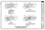
 Generalized Development Plan, Special Exemption Plat
 Existing Conditions
 Phasing Plan
Jeffrey M. Parnes
Chair, Sully District Council
Land Use and Transportation Committee
2004 ©SDC; last modified Friday, 22 October 2004
http://www.SullyDistrict.org webmaster@sullydistrict.org
modified by Jeffrey M. Parnes